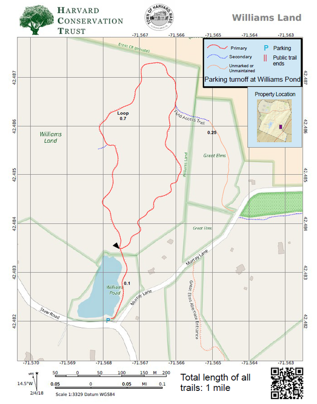
HARVARD TRAILS
  • Home
  • Map Index
  • Trails
    • Map Index
    • 1 - Cold Spring Brook
    • 2 - Old Mill
    • 3 - Harvard Park
    • 4 - Maxant
    • 5 - Blomfelt
    • 6 - Holy Hill
    • 7 - Mirror Lake
    • 8 - Kaufmann
    • 9 - Shaker Spring
    • 10 - Hermann Orchard
    • 11 - Black Pond
    • 12 - Prospect Hill
    • 13 - Pin Hill
    • 14 - Ohlin
    • 15 - Town Forest
    • 16 - Fruitlands
    • 17 - Coke
    • 18 - WestOak-Dunlap
    • 19 - Oxbow
    • 20 - Clapp-Scorgie-Tufts-Smith
    • 21 - Barba's Point
    • 22 - Small Nature Trail
    • 23 - Muller
    • 24 - Horse Meadows Knoll
    • 25 - Willard-Poitras
    • 26 - Williams
    • 27 - Burgess-Brown/Great Elms/Brehm/Eastern Greenway (Central)
    • 28 - Sprague
    • 29 - Callahan-May
    • 30 - Hoch/Harris
    • 31 - Bowers Springs
    • 32 - Powell-Reed-Abbot
    • 33 - Tripp
    • 34 - East Bare Hill Land
    • 35 - Delaney North
    • 36 - Delaney South
  • About
  • Contact

Map 26 - Williams

Picture

Rating Comments:  This is a very pretty site that begins at a small, but very beautiful pond where there is a small parking area.  The loop is a moderate length with the option of veering off a secondary trail that passes through an old field leading to Murray Lane.  Walking along Murray Lane is a joy being a short dead end with only a few homes. Across from there the trail joins Murray Lane is an easement over private property that leads to the large Burgess-Brown/Great Elms trail complex, giving you the option to cover a lot of ground.  The loop trail also has a spur that leads into the complex of fields that are hayed in the summer after the ground-nesting birds have fledged. This collection of fields is another opportunity to extend your walk seasonally. The very prominent drumlin visible from Stow Road is a favorite place for sledding in winter. Easy-Moderate.

​Trailhead Directions: Click here 


Nearby Trails:  Burgess-Brown/Great Elms

​Elevation gain: 120' along loop

Parcel size:  77.75

​​Prefer the classic hand-drawn map?
  Click Here

Conservation Land Use Rules: Click Here

Keywords:  longer walks possible, fields, pond, parking, peaceful, skiing, skating, sledding, birds

Picture

Click ​here for a printable map.
Williams PDF (292K)


Click Here for a downloadable GPX file to upload into your mobile mapping app.
Powered by Create your own unique website with customizable templates.
  • Home
  • Map Index
  • Trails
    • Map Index
    • 1 - Cold Spring Brook
    • 2 - Old Mill
    • 3 - Harvard Park
    • 4 - Maxant
    • 5 - Blomfelt
    • 6 - Holy Hill
    • 7 - Mirror Lake
    • 8 - Kaufmann
    • 9 - Shaker Spring
    • 10 - Hermann Orchard
    • 11 - Black Pond
    • 12 - Prospect Hill
    • 13 - Pin Hill
    • 14 - Ohlin
    • 15 - Town Forest
    • 16 - Fruitlands
    • 17 - Coke
    • 18 - WestOak-Dunlap
    • 19 - Oxbow
    • 20 - Clapp-Scorgie-Tufts-Smith
    • 21 - Barba's Point
    • 22 - Small Nature Trail
    • 23 - Muller
    • 24 - Horse Meadows Knoll
    • 25 - Willard-Poitras
    • 26 - Williams
    • 27 - Burgess-Brown/Great Elms/Brehm/Eastern Greenway (Central)
    • 28 - Sprague
    • 29 - Callahan-May
    • 30 - Hoch/Harris
    • 31 - Bowers Springs
    • 32 - Powell-Reed-Abbot
    • 33 - Tripp
    • 34 - East Bare Hill Land
    • 35 - Delaney North
    • 36 - Delaney South
  • About
  • Contact