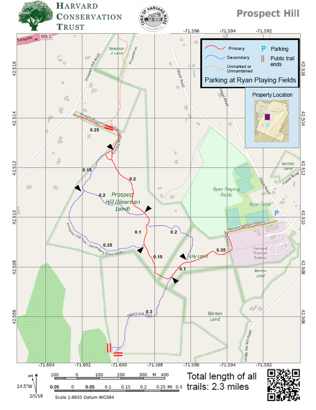
Map 12 - Prospect Hill

Rating Comments: Two main access points, one on Prospect Hill Road where at times it is possible to pull a car into the mowed area, or better, the large parking lot at the Ryan ball fields on Depot Road. From there, walk along the southern edge of the fields, turning left behind the DPW and Transfer Station, over a boardwalk adjacent to a marsh, then up onto the hardwood forest. Initially following an old cart path steeply up into the white pines that leads to the top of Dean's Hill, where there is a small field adjacent to two private orchards and spectacular views to the west. Views to the south are obscured by the Davis Orchard, which is private land and signed. A gate leading into Community Harvest, a non-profit orchard allows members of the Harvard Snowmobile Club to travel over a portion of they land.
The main network of trails traverses mostly hardwood forests with some steep sections. Beautiful lichen-covered rocky outcroppings and ledges are scattered throughout the site. One of the most beautiful woodland trail systems in town. Moderate.
Suggested Route: 1.8 mi; 240' elevation gain/loss. Click here for map.
Trailhead Directions:Click here
Nearby Trail: Pin Hill
Elevation Gain: 250'
Parcel size: 175 acres
Prefer the classic hand-drawn map? Click Here
Conservation Land Use Rules: Click Here
Keywords: dog-friendly, hills, view, parking, wildlife.
Dean's Hill History: In 2002, the town approved money for the purchase of the Dean’s Hill property, to be funded by the sale of town owned land on Stow Road. Because several of the property owners were residents of other states, this made a direct municipal acquisition complicated. The town asked the Harvard Conservation Trust to complete the acquisition, and then sell the land to the Town. After negotiations between the Harvard Conservation Trust and the seven property owners, the property was acquired in two transactions in 2003. On January 22nd, 2004, Harvard’s Community Preservation Committee voted to recommend to the upcoming Town meeting that CPA funds be used to complete the acquisition of the Dean’s Hill property. This funding, in conjunction with the money originally allocated to the town and some from the Town Conservation Fund, was used to acquire the property on July 15th 2004. The Warrant Article stipulated that the property would be subject to a conservation restriction held by the Harvard Conservation Trust.
The main network of trails traverses mostly hardwood forests with some steep sections. Beautiful lichen-covered rocky outcroppings and ledges are scattered throughout the site. One of the most beautiful woodland trail systems in town. Moderate.
Suggested Route: 1.8 mi; 240' elevation gain/loss. Click here for map.
Trailhead Directions:
Nearby Trail: Pin Hill
Elevation Gain: 250'
Parcel size: 175 acres
Prefer the classic hand-drawn map? Click Here
Conservation Land Use Rules: Click Here
Keywords: dog-friendly, hills, view, parking, wildlife.
Dean's Hill History: In 2002, the town approved money for the purchase of the Dean’s Hill property, to be funded by the sale of town owned land on Stow Road. Because several of the property owners were residents of other states, this made a direct municipal acquisition complicated. The town asked the Harvard Conservation Trust to complete the acquisition, and then sell the land to the Town. After negotiations between the Harvard Conservation Trust and the seven property owners, the property was acquired in two transactions in 2003. On January 22nd, 2004, Harvard’s Community Preservation Committee voted to recommend to the upcoming Town meeting that CPA funds be used to complete the acquisition of the Dean’s Hill property. This funding, in conjunction with the money originally allocated to the town and some from the Town Conservation Fund, was used to acquire the property on July 15th 2004. The Warrant Article stipulated that the property would be subject to a conservation restriction held by the Harvard Conservation Trust.
Click here for a printable map.
Prospect Hill PDF (312K)
Click Here for a downloadable GPX file to upload into your mobile mapping app.
